Nina Hut is a popular hut situated up the Nina Valley in Lake Sumner Conservation Area. The track provides a number of access points to a range of more challenging routes along the Nina River. It’s a common hike for school groups and Duke of Edinburgh Bronze participants to use as a qualifier hike . There isn’t a large amount of climbing along the track to Nina Hut. The bush provides good coverage from the sun, wind and rain making it a safe option no matter the weather. Although the track may be rough, it is well marked from SH7 to Nina Hut. Along the way, there is a swimming hole that provides a pristine spot for a swim on a hot summers day. Pack your insect repellant and towel for this trip, there can be an abundance of sandflies along the river and around the hut.

42°27′52″S 172°19′48″E
In Detail
Although DOC signs say that the hike takes 3 hours to reach the hut it took us a solid 4 hours to reach the hut both ways. Especially if you are thinking of doing this hike for the first time I would highly recommend allowing at least 4 hours if not more to reach the hut. The route is not a smooth graded walking track, but rather a rough hiking track with many tree routes, stream crossings and mud puddles to negotiate along the way. An intentions book is situated after the first swingbridge that you cross to give you an idea before you head in if there will be room at the hut before you get there. It’s especially useful if you are a large group and tossing up whether to stay in the hut or camp.

Getting There
Getting to the start of the Nina Valley isn’t extremely difficult. From Christchurch follow State Highway One until you reach the turnoff at Waipara to State Highway Seven. There is a pull-off near the New Zealand Deer Stalkers Association’s Palmer Lodge. Many parties will park under the trees in the area to ensure that they are not directly in sight of passing cars. It’s advised to take any valuables with you and stow any other items out of sight in your car. Lewis Pass is unfortunately renowned for cars being broken into.
Route
The track into Nina Hut is well marked with a number of further hiking routes branch off from the main valley route along the way up. The track begins north of Palmer Lodge marked by a small DOC sign. After crossing the swing bridge across the Lewis river the trail winds through the forest later joining the Nina River. Where the track first leaves the river near a grassy meadow you can find a good swimming hole. This section of track to the swing bridge is supposed to take approximately an hour. We found that it took closer to 2 hours to reach the swingbridge and then a further 2 hours to reach Nina Hut. The track into Nina Hut is not well-formed compared to the track to the swingbridge. There are many bogs and streams to negotiate along the way.
[wp_mapbox_gl_js map_id=”5732″ height=”800px”]
Weather
MARUIA WEATHERSH7 Swing Bridge
Getting to the very start of the track isn’t the most obvious if you’ve never been up Nina Valley before. There is a small DOC sign just up from the NZDA’s Palmer Lodge where the track begins. There’s about a 20-metre walk before you reach a swing bridge across the Lewis River. The humble swingbridge only has capacity for one person to cross at a time. If you’re a large group it’s a good idea to cross the swingbridge in waves to reduce waiting time. Across the other side of the bridge is an intentions book that has been placed at the start of the track to inform hikers of the intentions of others along the way. It’s a great way to check whether you’ll find yourself a bunk at the hut before you arrive.

Nina Valley Track
Between the SH7 swing bridge and Nina Swing Bridge takes 1 hour according to the DOC signs on the track. We found that walking at a moderate pace that it took closer to 2 hours to reach Nina swing bridge. Following the track, we made our way around the base of Mt Norma and onto the forest flats towards the Nina River. The track is very well-formed over the first couple of kilometres from a large amount of use that it gets. While we were out there were a number of polytech students conducting some studies in the forest close to the start of the track.


Bottom: The forest floor over the first section of track is smooth and soft under foot making for some easy walking
Walking along the Nina Valley Track during the summer there was not a large amount of mud that we came across early on. In the winter months and after extended periods of rainfall, the track can get mud logged. Logs have been placed throughout these muddy sections to help you from slipping and falling in. A good pair of walking poles or even a walking stick would be a valuable investment on this hike. Sections, where you may have to cross a stream, are bridged by fallen trees or from logs cut nearby.


Bottom: Lauren keeping balance while crossing a boggy part of the track
Waterhole
As you approach the Nina River there is a beautiful swimming hole close to a clearing. A short track leads down to a rock where you can strip off your clothes and leave your pack if you’re up for a swim. In the summer months, the water is refreshing but never too cold. There can be a lot of sandflies around the river depending on the climate. On our way to Nina Hut sandflies swarmed the area and we didn’t dare go for a swim. Returning to the same spot a day later there were far fewer sandflies buzzing around.


Bottom: The nice calm patch along the Nina River deep enough to dive in for a good swim
Nina Swing Bridge
From the Nina swing bridge, there are another 2 hours of walking to reach the hut. We found that the DOC sign agreed with us on the timing for this section of track. The swing bridge is limited to one person crossing the swing bridge at a time. For larger groups, this part may take a while to get everyone across. Around the bridge, there are variety of natural features for seats to rest, grab something to eat and drink.


Bottom: A friendly Robin checking us out from the swing bridge fastenings
Track to Nina Hut
There is a section of the track following on from the swing bridge which has been destroyed from a collapsed bank many years ago. Tucked around the bushes a rough track marks a short detour before regaining the actual track again. The bank has remained like this since I was first here in 2012 and in 8 years the beaten up detour still exists. The forest soon after opens up some smaller clearers around a similar elevation of the river before then entering the bush and climbing.


Bottom: Lauren negotiating a steeper section of track along the way to Nina Hut
Mud & Streams
It’s difficult to realise the differentiate parts of the track and how close you may be to the hut between the Nina Swingrbridge and Nina Hut. There are parts of the track where you climb, and others where you head back down towards the river’s edge again. Much of this track is covered with roots springing from all different directions. Getting a good footing makes this section take longer.


Bottom: Avoiding getting too stuck in the mud
Even with all the trees around there is still a lot of mud that you seem to encounter on the ground. Tracks have been carved into the side of the trail in an attempt to avoid many of the mud puddles. Although they can be tricky to follow they do save yourself from getting dirty boots. Through the middle of these sections of mud, a number of logs have been placed to give you a stepping stone towards the other side. One good indicator that you can use to determine how far you are from along the track is by counting the number of side streams you’ve crossed. There should be three side streams that you come across between Nina Swingbridge and Nina Hut.


Bottom: Climbing back onto the track after crossing a small stream
Climb to Nina Hut
You’ll know that you’re getting close to the hut when you have to start climbing quite steadily. There are only about 60 metres of elevation gain between the forest floor and the small knoll that the hut sits on. It’s probably the biggest climb that you have to tackle over the entire day, likewise the descent the next morning is reasonably fast. From the top of the knoll, there are only a couple hundred metres further to Nina Hut.


Bottom: Lauren standing atop the knoll not far from Nina Hut
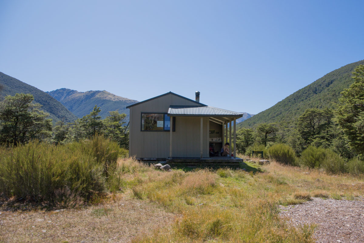
Nina Hut
Nina hut is a 10 bunk hut with Maori style bunk beds constructed back in 2002 and is frequently used. It has a fireplace, a basin just outside the hut, woodshed and a classic long drop close to the hut. For a standard hut, it has some extremely good facilities on offer. Unfortunately, it’s a hot spot for a lot of sandflies, making it unbearable sometimes to be outside without a good amount of insect repellant. Fortunately, the netting around the hut is well intact keeping the sandflies out. The best idea is to keep the door closed as much as possible, especially during the evening and morning when the temperatures are lower and the air is damp.


Middle Left: Staying overnight at Nina Hut costs a standard hut ticket ($5 each)
Middle Right: Putting two hut tickets as our payment for our overnight stay at Nina Hut
Bottom:The Maori style bunks in Nina Hut
Groups who regularly use the hut have been kind enough to leave behind a wide range of pots and pans that you can use and return during your stay. Ensure that you clean the pan and return it just the way as you found it. If you find the water tank empty or the water contaminated, there is a stream about 10 minutes up the trail to Devil Skin Saddle Bivouac. The water is fast-flowing and is a reliable source of clean water, otherwise, water can be taken from one of the side streams back down the track towards Nina Swingbridge.


Middle Left: Morning porridge with coffee and tea
Middle Right: Hut tickets and the intentions all filled out
Bottom: Nathan (the Author) ready to head back towards the car
Return Journey
The return journey is always a little easier, most of the way you are heading back down towards the car, even though you hardly climb very much during the entire outing. Even though you are under the bush during the earlier hours of the day it still tends to still be quite warm during the summer months. The side streams heading back towards the swingbridge are usually a good source of water. Another source of water is to take it from the stream along the track up towards Devil Skin Saddle Bivouac.


Middle: Lauren taking a lunge through the mud along the track
Bottom: Nathan making his was along Nina Swingbridge
The water hole is a great place to stop by on the return journey, refreshing you before you drive on home. We found that on our way back there were not nearly as many sand flies here. The water is refreshing but you can jump out and hop in multiple times before heading back out for the car. Take the time to sign off the book at the end of the trail before you head home as well. If you ever found yourself lost, it provides your intentions in the DOC book provide a useful aid for search and rescue teams. It’s a good way to comment on how your trip went and point out anything to fellow hikers.


Middle Left: Housed in a wooden box sits the intentions book at the start of the track
Middle Right: Details of our journey being recorded in the hut book
Bottom: Final few steps from crossing the swing bridge back to SH7