Mount Pirongia is an extinct volcano near Hamilton that is popular among Hamiltonians for its easy access and spectacular views. From the summit on a clear day, you’ll be treated to views across the Waikato and out to Raglan along the track. There are several different tracks that all lead to the summit of Pirongia, which eventually lead on to the twenty bunk, Pahautea Hut. Bookings for the hut must be pre-made through the Department of Conservation online booking platform. In this first excursion to Mount Pirongia we took the shortest (and possibly steepest) route, following the Tirohanga track. No matter which tracks you take, you’ll find yourself tackling a fair amount of elevation gain. When you look out over the Waikato region from the summit, you’ll have earnt it.

37°59′35″S 175°05′45″E
In Detail
Hiking up Pirongia is also commonly walked a day hike. With a lighter pack you’ll fly along the trail a lot faster compared to an extra 10+ kg on your back full of sleeping and eating gear. You’ll likely be able to remove half an hour to an hour from the time above to reach the hut. Alternatively, if you’re keen to head up Pirongia for the weekend but can’t find space in the hut, there are camping sites can be booked through the Department of Conservation website for a peaceful night’s sleep. The campsites are located less than a minutes’ walk from the hut and feature a small shelter for cooking.

Getting to Corcoran Road Carpark
From Auckland take State Highway South towards Hamilton. As you approach the city take the exit marked State From Auckland take State Highway 39 through to Whatawhata taking a further right hand turn onto State Highway 23 before turning left onto Te Pahu Road. Follow the road until you reach a long straight through the small town of Harapepe where you’ll need to make a hard right onto Corcoran Road. The road is easy to follow with a couple of tight bends and a little rougher around the carpark but manageable in any car.
Mount Pirongia via Tirohanga Track
The track up to Mount Pirongia begins gently through the bush. The ascent isn’t hefty at first but it’s noticeable. As you approach the summit of Ruapane you will start to break into a good sweat. The track takes a ride up and down two camel’s humps before ascending on up to Tirohanga. Descend once again and when you get back to climbing, you’ll be well on your way to reaching the summit of Pirongia. From the summit viewing point (a metal viewing platform structure) there is a further sharp descent, and some mud plugs to dodge before you arrive at Pahautea Hut.
[wp_mapbox_gl_js map_id=”9810″ height=”800px”]
GPX file download for Tirohanga Track
Mount Pirongia Weather
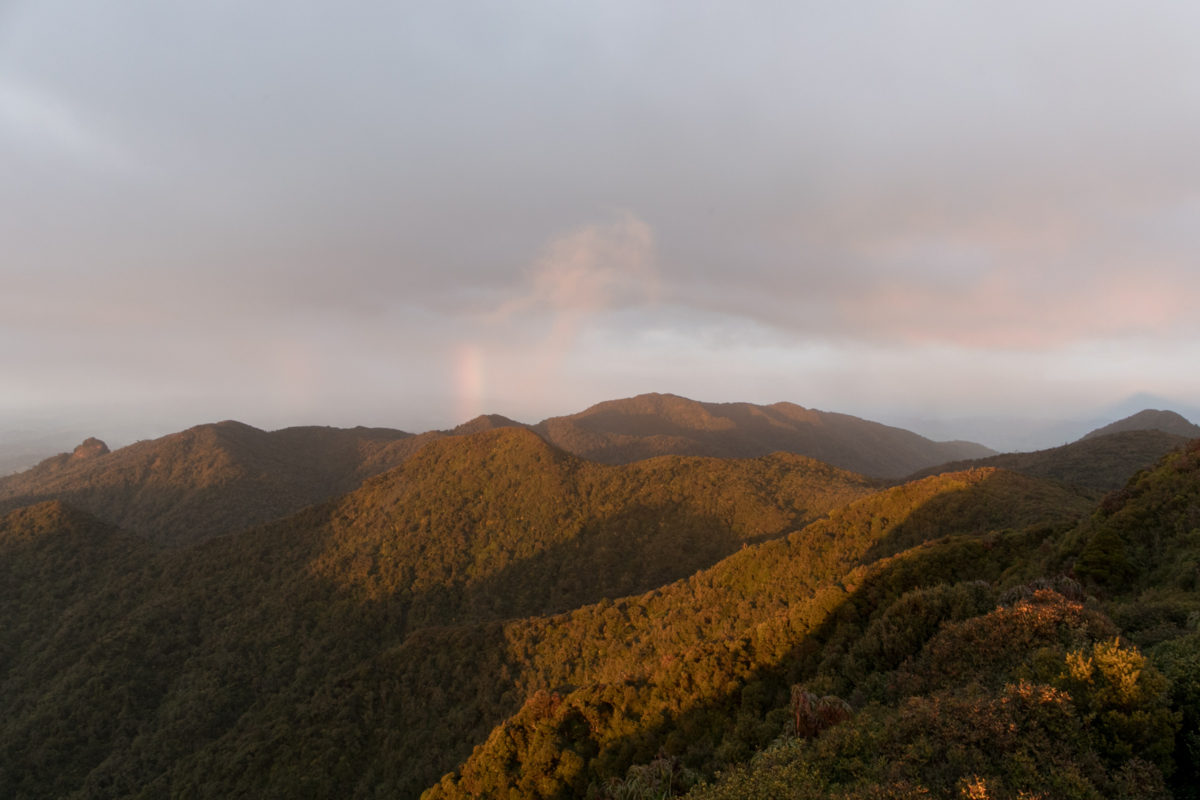
Weather on Mount Pirongia can be walked in most weather conditions. If it’s a little wet it can be a little more Weather on Mount Pirongia can be walked in most weather conditions. If it’s wet, it can be a little more miserable. Roots and holds that you must clamber over are often more slippery and should be taken with more care. If it’s not pouring with rain the tree cover is ample enough to keep you from donning your raincoat. When it’s cloudy you won’t get the same views as you do on a beautiful sunshine day, however, you might just catch the tail end of a rainbow. Certainly, on a good day the views stretch from ocean to ocean and are well worth the climb.
Tirohanga Track to Mount Pirongia
The track begins taking you through the forest. The tree cover is large stretching up as you make your way through the well carved track. People talk about the infamous “Pirongia Mud”. Although you might get a small taster of this at the start, you’ll find that it’s usually not that bad comparatively to the track nearing the hut. The track throughout this section is relatively well formed, wide being so close to the road end, hence well used and easier to access. After approximately half an hour you’ll reach a junction that connects the Tirohanga Track and the Ruapane Tracks together. Continue straight. If you’re not climbing, you’ll know that you’ve gone the wrong way.

Ruapane
Ruapane is the first peak that you climb on your journey up to Pirongia. At this point you’ll have made solid progress up the mountain relative to Pirongia. Unfortunately, from here the terrain becomes more challenging with many more descents and ascents to be complete before reaching the summit. Enjoy the views from Ruapane, grab a snack and hydrate before continuing onto some more challenging climbs.


Top Right: The summit marker atop Ruapane 723m above sea level
Bottom: Looking north out over the Waikato farmland
The fun begins here. From the the summit of Ruapane, there’s a sharp descent back down into the forest for a hot minute before you begin climbing a rock face. Along these section are bolted chains fitted to the rock to help you make The fun begins here. From the summit of Ruapane, there’s a sharp descent back down into the forest for a hot minute before you begin climbing a rock face. Along these sections are bolted chains fitted to the rock to help you make your way up and down. Below you can see the initial two-part section on the way to the next peak of Ruapane. Following there is another small descent to be made before you carry on through the forest finding your way along to Tirohanga.

Tirohanga Track
The Tirohanga track continues with a shallow decent back into the forest before the track begins to get more gnarly and less well trodden. Fortunately from all the bush that grows around the track, you’re never short of anything to hold onto The Tirohanga track continues with a shallow decent back into the forest before the track begins to get more gnarly and less well trodden. Fortunately, from all the bush that grows around the track, you’re never short of anything to hold onto. Keep an eye out along the way for supplejack shoots. These are fresh shoots are edible parts of the supplejack vine that taste very much like green beans. Eat them fresh when you find one during your walk for a nature boost.


Top: Eden and Deb making their way along the chained climbs up and along the track
Bottom Left: Looking down at a marker put in place by the Land Survey Department many years ago
Bottom Right: A quick over the shoulder look towards where the track continues
Tirohanga
Tirohanga isn’t marked by any DOC sign nor any homemade bush signage although there is a visible track that leads from the track up the steep rock face to the summit. You’ll descend alongside the mountain which has a slight overhang fTirohanga isn’t marked by any DOC sign nor any homemade bush signage. There is a visible track that leads from the track up the steep rock face to the summit. You’ll descend alongside the mountain which has a slight overhang feel to it as you progress onto Pirongia. Where the goats track begins there is enough room to sit-down and have yourself a nice picnic lunch if it’s that time of day. Continuing to Pirongia the trail puts up some challenging terrain to tackle along the way.


Bottom: Ayla and Hannah negotiating one of many tree routes along the trail
Mount Pirongia Summit
The viewing platform near the summit of Mount Pirongia is one of the best spots for taking in the views during the hike. Both on the way to Pahautea Hut and the return journey back to Corcoran Carpark all we could see was white mist. If we were lucky, you could make out the outlines of some of the immediate ridges. The photos below were taken at sunrise of the morning we left the hut before the cloud entirely set in.


Middle: The sun rising up from the sea before it gets buffered by the clouds
Bottom: Looking south-east out over the Waikato from the summit of Pirongia
Pahautea Hut
Pahautea is the only hut in Pirongia Forest Park that you can stay at. Nearby there are camping facilities including pads where you can pitch a tent, get running water and do your cooking. If you’re planning on staying in the hut you will need to pre-book your spot using DOC’s hut booking system beforehand to ensure that you have saved yourself a spot in the hut and you have a mattress to sleep on when you arrive. From the summit of Pirongia there is only a further half-hour of walking with a big pack, or around 15-20 minutes if you’re walking fast. During busy periods a Hut Warden is likely to be present checking everybody who’s staying has booked themselves a bunk for the night.

The hut is tidy for a standard category hut. Although there aren’t the spare pots and pans that you might find at a remote backcountry wilderness hut the kitchen has running water plumbed to it and a sink to wash your dishes in. There are two bunk rooms. The larger of the two is arranged in a Māori bunk configuration and has 16 bunks and the smaller is a 4-bunk bed style room shown below. Before you enter the hut there is a dedicated room to remove your boots out of the elements before entering the hut. Outside you’ll find a further basin. Three standard decomposing toilets are located along a board walk not far from the hut.


Clockwise from Top Left
Pahautea Hut in the rain sitting waiting for it’s next lot of guests ready to be occupied
A quick window selfie never harmed nobody before setting off down along the trail
A look out the window from the kitchen area of the hut
Looking through the door at one of the two bunk rooms, the other is a larger Maori Bunk configuration
Return Journey via Mount Pirongia Summit
The return journey back from Mount Pirongia is just as challenging as the climb up to the summit. Certainly, the cardio and panting subside during this part of the journey as you find your way through the bush but keeping your footing. Using those big muscles to stabilise yourself along the trail is essential. Taking care where you place your feet and ensuring you have a good grip will help you take on the challenge with ease.


Left: Saranya & Deb navigating along the track and through the forest
Right: Saranya taking on the challenge of abseiling down the rock face along the track
Mount Pirongia Crew
It was a pleasure taking this group of 15 up to Pahautea Hut for the night, although feeding a crew of fifteen troopers is rather difficult with one medium/large sized pot we did manage to crank out a good feast in the end. Here’s to many more adventures with great people and to sneaking in this epic North Island hike with friends both new and old before lockdown had us cooped up inside. Appreciate you all for coming out and thriving.
