Camp Stream Hut is an old backcountry ski touring hut situated in Te Kahui Kaupeaka Conservation Area. The hut is the final cabin before reaching the end of the Rangitata-Tekapo section of Te Araroa. It’s only a short walk from the road end which is relatively easy walking through the tussock lands. The hut is from the 19th Century making it quite a relic in amongst the mountains to have survived for so many years out in the elements. The walk into the hut is short and cheerful with an almost line of sight view between the hut and the trail making it an adventurous hike for someone without a large amount of experience. The large rolling hills and surrounding mountains are known among hunters for prime territory for good hunting. If you’re staying in Tekapo for a while Camp Stream Hut is well worth putting on your list.
Time
2 hours
Distance
5.23 km
Ascent
192 m
Map
BY17
Grade
Easy

43°48′55″S 170°38′45″E
In Detail
Depending on the status of the access road to Roundhill Ski-field will determine where you will be able to start the track. In our case the gate was closed and locked to Round Hill Skifield due to insufficient snow on the ski field. Instead we decided to ride our bikes up to the start of the track before ditching them part way along before the descent. It’s far easier leaving them at the start of the track than trying to lug them further along the track. If your lucky and the gates open a great option is to let one person from your party drop you off at the start of the track and their pack whilst they either run or bike back to the start without their gear. The Richmond Track starts from Lilybank road and crosses the access road making for an extension option to your adventure.

Getting to Camp Stream Hut
From Christchurch you must follow State Highway One down to Rangitata. There is a clear turn-off sign with the road sign pointing towards Aoraki (Mount Cook) and Geraldine which marks the beginning of State Highway Seventy Nine into Mount Cook National Park. Follow the road signs as you stay on State Highway Seventy Nine until Fairlie. Take a hard right when you reach the or take a quick stop at the Fairlie Bakery. Follow the road through Burke’s Pass to Lake Tekapo. Just before you arrive at Lake Tekapo township there is a road off the main highway called Lilybank Road. Turn right here and follow the road right up until you reach the access road up Round Hill ski field. The gate may be locked at this point in which case you have approximately 2 km walk ahead of you.
Camp Stream Hut Route
The route from the locked ski field gate (if you can get past it) can begin with an uphill walk along a gravel road or rather a granny gear slog up the skifield access road to the start of the track. It’s tough and definitely not an easy climb on the bike with a pack but it does speed up getting both up and down the hill at either end of the hike. From the beginning of the track you’ll follow along a plateau before descending steeply down to Coal Stream. Follow Coal Stream upstream for a few hundred metres before crossing and finding your way further up along Camp Stream. Follow Camp Stream up along the True Left of the stream where you will find remnants of the track with damage due to wash out. Eventually you will reach a knoll with a short climb to Camp Stream Hut.
[wp_mapbox_gl_js map_id=”8009″ height=”800px”]
GPX file download for Camp Stream Hut
Camp Stream Hut Weather
The weather through to Camp Stream is usually relatively consistent. There is still some distance between the main divide and the track where weather is often quite volatile. In summer the track is with far less water in the streams and rivers than what you might usually see. In winter time often you will see patchy snow around, depending on the conditions at Round Hill Skifield it will be a good indication of what the snow level is like in the area.
Round hill Ski Field
As mentioned twice above, there is a gate pat way up the access road to Roundhill ski field. At times when the ski field is closed the road is often also closed not allowing vehicles past that point. In our case we had brung bikes intending to tackle another trip along the way. It is a granny gear on the bike and you’ll need to muscle it up the steep hill with a heavy pack. If cycling isn’t your forte I would suggest rather walking the section up to the start of the track. Enjoy the views on a good day out over to the Godley and Macaulay Rivers.


Bottom: Looking out over the Godley and Macaulay Rivers from part way up the access road
Te Araroa Trail to Coal River
The track to Camp Stream Hut linked by Te Araroa begins along a plateau along the base of the Two Thumbs Range. It has a beautiful outlook over to the Sibbald Range and the Liebig Range that link up to the main divide between the east and west coast of the South Island. Between Ed & I we found that the first section along the plateau is easy enough to ride along, the walking track is relatively smooth and easy to follow. It’s the steep descent down to Coal Stream in which you realise that unless you are an off piste downhill mountain bike rider, then you’ll be likely heading down to meet the rescue chopper. It’s a steep downhill, although the track is well cut and easy enough to find where you should go.


Middle: Looking out towards the surrounding mountains that make up the Richmond Range as the sun sets
Bottom: Ed attempting the first section of the Te Araroa trail towards Camp Stream Hut
Coal Stream to Camp Stream Hut
Descending to Coal Stream you’ll have to travel slightly upstream before crossing the river to follow the true left (left as if you were following the flow of the river). From here onward follow the orange poled markers as best you can. Due to the limited hours of daylight hiking this in winter we ran out of daylight very quickly through these parts. We navigated entirely off trail having lost the marked track yet still between map and natural features we were able to find our way to Camp Stream Hut without too much difficulty.

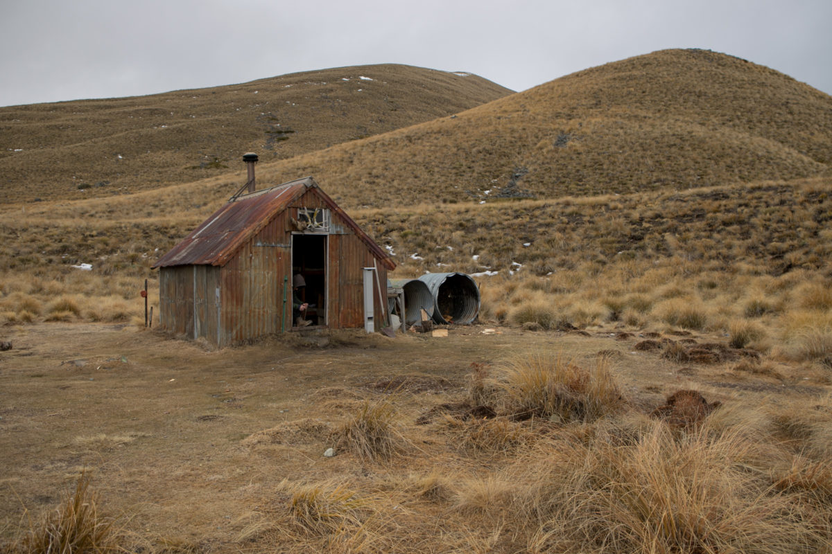
Camp Stream Hut
Camp Stream Hut is a small hut with only enough room to comfortably accommodate six people at the absolute maximum. There isn’t a large amount of room to move around the hut at all with a small bench inside alongside a wash basin outside and and a couple of old pots and pans that could do as an emergency pot on the fireplace for heating a meal or some water after a wash. There is plenty of wood that gets restocked by the Mackenzie Alpine Trust who recommend a donation of $10 per person for a night at this little alpine hut. Donations can be made to the following account number of rather placed in the honesty box outside the hut.

If you want to do a good deed, chopping a good bit of firewood, drying some out by the fire for the next person is always very much appreciated by the next guests. The hut is literally a tin shack so you’ll need to make sure you have a good warm sleeping bag to keep you warm during the night. Water can be collected from the nearby camp stream which is a little bit of a walk away. It is well worth bringing a water bladder or a fillable water container to reduce the number of trips you need to do. There are buckets near the hut positioned to catch rainwater from the roof, however it would not be recommended to drink this water at all.


Clockwise from Top Left
Ed attempting to scrub off as much of last nights dinner as possible before we delve into breakfast
Chopping a few more pieces of wood to make up for the wood we consumed the previous night on the fire
Camp Stream Hut’s name plate on the wooden door of the old hut
Zach lacing up his boots up before we begin the next day out hiking back along the trail towards the bikes & then onto the car
Return from Camp Stream Hut
The return journey back from Camp Stream shows far more of the route that you should take too and from the hut. As seen in the photo below Camp Stream can be seen flowing out through the gorge and cliffs towards Coal river. The mountain range in the distance is the steep ascent to the plateau which then ends at the road. From the hut you can almost see the entire route you must take to get you back to civilization.


Middle: Ed and Zach deliberating over how to cross the side stream without getting there feet wet
Bottom: Zach & Ed following the riverbed along to find the track in amongst the tussock
Once you are down following the river back there are a couple of sections where the markers seem to have been washed out in a landslide and disappear. It’s easy enough to know which direction you are heading in but it’s obviously a lot harder when you are wading through tussock trying to avoid getting your feet wet amongst it. There are a couple of key points climbing up the river bank and staying on the true left will help. Cross slightly upstream of where Camp Stream meets Coal Stream and venture down the track.


Clockwise from Top Left
The two troopers stop for a quick portrait together
Discovering the track has washed out and requires us to dig out feet in as we find our way back onto the track
Looking up along a hill with an old beaten wire fence in the middle of the backcountry
Looking back across Coal Stream towards unnamed peak pt 1513
Coal Stream Climb
The final climb up to the plateau is certainly a little more of a challenge, but once again it is short lived and rewards you with some hearty views as you look back out over the plateau towards Camp Stream Hut. As always with a big climb, take your time, and enjoy your progress along the way. Appreciate how far you’ve come even if it ain’t much of a challenge for you.


Bottom: Zach stopping to check back on the rest of the boys as we collect our bikes we abandoned along the way
Road End
Finally you will have made it back to the road end after winding your way along the plateau for a little while. Once again you can easily make your own trail along sections of this once you can see the road. There is a small stream between the road and the track that you’ll need to tackle before you are running (or spinning) your way back to the car. To lengthen your walk you can continue on along the Te Araroa Trail (also known as the Richmond Trail) which will take you through to Lily Bank Road for another 13 km. This trail can be mountain biked if you are looking for an MTB ride.


Clockwise from Top Left:
The DOC sign with times for Camp Stream Hut and Red Stag Saddle. Zach’s bike right where he left it the previous day
Ed contemplating how he’s going to get back down the road on his semi-broken mountain bike to the car
Zach taking a longer approach back to the road end arrives at the signposted Te Araroa DOC sign
Ed throwing up a couple shukkas to celebrate the end of the trip and a hoon back down the road to the car
Camp Stream Hut Crew
These two troopers pulled through a massive ride up the access road on half broken bikes to then suffer cold feet in the darkness of night. Mad chats late into the night at Camp Stream Hut and plenty of good memories from such a topsy turvy trip. From expectations of biking to the hut turned to Nathan (the Author) walking in beat-up slip on shoes because he left his shoes in the car. From snow coming down and the a mystical but cold morning back out. The trip was nothing but big grins smiles and a trio of hungry stomachs to feed by the time we reached Tekapo.
