Sebastopol is a mountain peak in Mount Cook National park that’s achievable for experienced hikers and those after an adventure. It begins with a hike up along the well-formed and maintained Red Tarns track to the tarns, before continuing off trail along a route. It is a great way to escape the masses whilst getting some of the best views that can be reached by a hiker in Mount Cook National Park. During the winter months snow covers the route above the tarns and the trail becomes a mountaineering route. It is known to be a ‘warm up route’ for mountaineers before they attempt larger climbs due to the short length of the trail. This hike isn’t for the faint hearted, there are many steep drops and sections that should be attempted with calculated risk.

43°44′58″S 170°05′55″E
In Detail
From doing background research before attempting this hike, there is a large variation in the timing that it can take to reach the summit of Sebastapol. A Wilderness magazine article claimed that it would take 5 hours return, however, it took us approximately 3 hours return to the car. Zach (featured in this post) managed to run up to the summit sub one hour. A lot of this will vary with the size of your group, experience, navigation skills and weather conditions. Summiting Sebastapol is best done in good weather. If the clouds comes down knowing your route, is important to ensure you reach the tarns. Going further there is potential to reach Mount Annette from Sebastopol although technical climbing equipment would be required. From Mount Annette travel to Mueller Hut is possible.

Getting to Sebastopol
There are a number of different spots in Mount Cook village to begin your hike up to Sebastopol. A reasonable amount of parking and a great stopping point is at Mount Cook Public Shelter. Rubbish bins are available here along with toilet facilities and a sheltered space to eat and drink. The Red Tarns track begins behind the shelter along a paved walkway from the parking area. A small DOC sign marks the beginning of the track pointing you in the right direction.
Sebastopol Route
The route to the summit of Sebastopol begins with walking along a pathway which makes up a part of the Governors Bush track to where the Red Tarns track begins. The track is well looked after by the local Department of Conservation (DOC) office and is a quite literally ‘a walk in the park’. Once you reach the Red Tarns, a small track aside of the track leads through the surrounding wetland and begins up a scree slope. An alternative route through the bush exists (on the left towards the summit). A large rock marks the beginning of a cairned trail through scrub and rocky outcrops. Approaching the summit travel through a narrow chute (down & then back up) before reaching a ridge ling onward to the summit. Sebastapol’s summit is marked by a large rock pile.
[wp_mapbox_gl_js map_id=”8697″ height=”800px”]
GPX file download for Sebastopol
Mount Cook Weather
Weather in Mount Cook national park can be changeable at the best of times. Even on these shorter hikes ensure you are prepared for all conditions and check forecast before you head off. In winter time it’s not surprising to see snow around the Red Tarns. Even in the summer there are chances of snow falling and settling along established hiking tracks in the national park. Ensure you carry at least one extra warm layer of clothing, and a windbreaker/rain coat in case the weather turns.
Red Tarns Track
The track to Red Tarns begins with a stroll along pavement, a section shared with the Governor’s Bush track. The track then makes it’s way along a footbridge across black birch stream before venturing into the forest as the climb begins. The entire track has cut steps with the track being easy to follow right the way along. Once you reach the top of the stairs, the walk is gravelled and board walked around the tarn. A couple of wooden benches are placed along the walk make for a comfortable spot to rest the legs whilst enjoying Mount Cook National Park. For more information on the Red Tarns section of the track refer to the post on Adventures from the South.


Top Right: A hiker making his way along the track through the switchbacks
Bottom: The Red Tarns with Aoraki (Mount Cook) in the background
Scree Slope from Red Tarns
From the Red Tarns, quite an obvious scree slope can be made out that leads up towards a ridgeline. A distinct unmarked route has been carved into the rock scree that is easily followed. Parts of the slope are loose and will have you slipping up along the way. Towards the left of the scree slope, shrubs and grass cover the mountain slope. Along the fringes exists another route which you can followed up and along to the ridge line. Either way, eventually you should reach a large distinct rock where you will be sure to find a cairn marked trail towards the summit.


Clockwise from top left
The boys starting to make their way up along the scree slope along the first section of the hike towards the summit
Richard easing his legs along the scree slope, immersing himself in the surrounding view
Ed making his way through the shrubs alongside the scree slope, an alternative way to ascend towards the ridge above the tarns
Looking across the ascent route, Zach towards centre frame making his way through towards the ridge
Sebastopol Scrub & Cairn Route
Along the ridge you’ll find the route starting to ascend across a number of switchbacks through the scrub that covers Sebastopol. Looking back down the mountain you’ll find yourself above a second plateau of ‘Red Tarns’ right above a number of renowned climbing routes in Mount Cook National Park. Throughout this section it can be easy to miss a cairn along the way, however, if you’re approaching from the right direction following the ridge eventually you’ll reach the summit. Pause and appreciate how far you’ve climbed along the way. Aoraki, Mount Cook along with the Tasman Lake is visible during the climb.


Middle: Scrub, grass and moss covering the surrounding mountain leading up towards the summit of Sebastopol
Bottom: A second plateau of tarns that complement the Red Tarns with Aoraki (Mount Cook) in the background, Tasman Lake seen to the right
Rock Scrambling
Scrub begins to recede as you approach the bluffs. Extreme caution is required throughout this section especially if you’re group hasn’t brought helmets along for the trip (as we did). Allow plenty of space between each of the members in your group. Keep an eye out for cairns throughout this section, amongst all the rocky outcrops they can be difficult to distinguish and pick-out as you find your way.


Clockwise from top left
Searching for switchbacks getting closer towards the bluffs that surround Sebastopol
Ed followed by Richard clutching onto the rock as the boys try to determine the route onward
Richard trying to make his way through the terraced
Zach checking out a cairn perched out in the open on his way up towards the top of the
The final crux of the entire hike is a steep and narrow scree chute that you must cross before reaching the final ridge to the summit of Sebastopol. Tuck away any loose gear that you may be holding on to before crossing this section. A conservative approach is to allow one party member across the void at a time to ensure no large rocks come crashing down. Exit from the void following the ridge onward as it leads you on to the summit. The route will become apparent from here onward.


Top Right: Richard dropping through the rocks during the ‘sketchiest’ section of the track
Bottom: Zach followed by Ed making their way along the final ridge, the summit of Sebastopol seen partially hidden towards the left of the frame
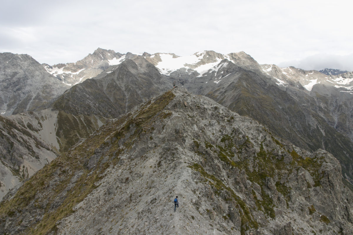
Sebastapol Summit Approach
Finally the very last climb you’ll do is between the false summit peak next to Sebastopol much like a camels hump. Once again the ridge is highly exposed to the wind. Ensure you take care of your footing throughout this section. At the same time, appreciate the three-hundred and sixty degree panoramic views that you have earned by reaching the summit.


Top: Ed and Zach stand on the summit of Sebastopol while Richard makes his way along the
Bottom Left: Looking across the ridge towards the summit of Sebastopol where Ed and Zach standing atop Richard finding his way up
Bottom Right: Richard pushing up off the rocks on the final push to the summit. A cairn above him marks the route up
Sebastopol Summit
The summit of Sebastopol is home to one of the best panoramic view points that a skilled hiker can reach. Sebastopol is certainly a step-up from the hike to Sealy Tarns, with a number of exposed sections and route finding skills essential throughout the hike. On a clear day you’ll be able to see from Lake Pukaki, right the way around to the Mueller Lake and Whitehorse Hill. Aoraki (Mount Cook) being the centre piece in the views throughout the hike is the crown jewel amongst the mountain top views.


Bottom: Mount Cook and Tasman Lake and Lake Pukaki seen together in a panorama
Return Journey
The return journey is significantly faster than the ascent to the summit of Sebastopol. Locating the route back down requires more effort as multiple animal tracks exist along the way back down. Locating cairns can be much more of a challenge too. Ensure you reach the major milestones of the route, the scree chute and the rock before the scree slope descent. Each of these two milestones will ensure you reach the Red Tarns without too much difficulty.


Middle: Following the ridge back down Tasman valley and lake seen in the background
Bottom: The boys leading out along the ridge,Lake Pukaki seen towards the right of the frame
Descending the Scree Chute on Sebastopol
The scree chute on the descent is even more dangerous on the descent compared to the ascent. Dislodging a rock onto someone with their back to you can easily do some significant damage. Take this section one at a time to avoid any until you are out of the line of fire. Enjoy the views while you wait for the rest of your crew. Allow your knees to rest along the descent and enjoy your surroundings.


Bottom: Zach following his way down through the switch backs as we descend back down towards Mount Cook village
Descending from the Red Tarns
The return journey back to the car park is a straightforward walk down. With bad knees it can be a hard time managing so many steps back down towards the car park. Descending is a lot faster than the hike up, with well defined steps making the track almost a run down. Appreciate and savour those views down to the car park.


Bottom: Ed making his way down the final few steps before finishing a trip up & down Sebastapol
Sebastopol Crew
Shout out to Ed, Zach and Richard who after an overnight hike up to Canyon Creek, a nights sleeping out at Whitehorse Hill Campsite still managed to muster the energy for yet another solid hiking adventure. The Tigers of Waitangi along with the were well earned back at the car, along with plenty of peanut butter/Nutella that got demolished on Lebanese bread. Here’s to more mountain summits and even more epic adventures in the beautiful Mount Cook National Park.
