The Red Tarns in Mount Cook National Park are an arrangement of red pigmented tarns with a view overlooking Mount Cook. The track to Red Tarns is a walking track, maintained to a high standard by the Mount Cook Department of Conservation. It is a great alternative to the more widely known Sealy Tarns Track in Mount Cook National Park. The views out over to Aoraki Mount Cook aren’t quite as picture perfect as Sealy Tarns, however, if you do want to escape the crowds and enjoy a more peaceful hike in the national park, the Red Tarns are an ideal option. If you’re looking for a more challenging route, the Red Tarns track makes up this first section of the route up to Sebastopol (or Mount Sebastopol). The route is a challenging day hike that takes approximately 3 – 4 hours.
Time
1.5 hours
Distance
3.81 km
Ascent
260 m
Map
BY15
Grade
Easy

43°44′51″S 170°05′54″E
In Detail
Within Mount Cook National Park there aren’t many hikes you can tick off before you retrace your tracks again. Large mountains rising up from the plains aren’t forgiving and don’t allow for many bush walks. Rather there are many mountain climbs. The Red Tarns track is a less popular track which that gives you the opportunity to walk a track that’s slightly easier than the Sealy Tarns Track but a step up from the classic Hooker Valley Track. If you want to avoid the crowds and explore ‘backcountry’ Mount Cook National Park, tackling the Red Tarns track is a great place to start. Be prepared for a lot of steps and a decent amount of elevation gain over a short distance.

Getting to Red Tarns
There are a number of different spots in Mount Cook village to begin your hike up to the Red Tarns. A reasonable amount of parking and a great stopping point is at Mount Cook Public Shelter. Rubbish bins are available here along with toilet facilities and a sheltered space to eat and drink. The Red Tarns track begins behind the shelter along a paved walkway from the car parking area. A small DOC sign marks the beginning of the track points you in the right direction.
Red Tarns Route
The track to Red Tarns begins with a stroll along pavement, a section shared with the Governor’s Bush track. The track then makes it’s way along a footbridge across black birch stream before venturing into the forest as the climb begins. The entire track has cut steps with the track being easy to follow right the way along. Once you reach the top of the stairs, the walk is gravelled and board walked around the tarn. A couple of wooden benches are placed along the walk make for a comfortable spot to rest the legs whilst enjoying Mount Cook National Park.
[wp_mapbox_gl_js map_id=”8624″ height=”800px”]
GPX file download for Red Tarns
Mount Cook Weather
Weather in Mount Cook national park can be changeable at the best of times. Even on these shorter hikes ensure you are prepared for all conditions and check forecast before you head off. In winter time it’s not surprising to see snow around the Red Tarns. Even in the summer there are chances of snow falling and settling along established hiking tracks in the national park. Ensure you carry at least one extra warm layer of clothing, and a windbreaker/rain coat in case the weather turns.
Red Tarns Track
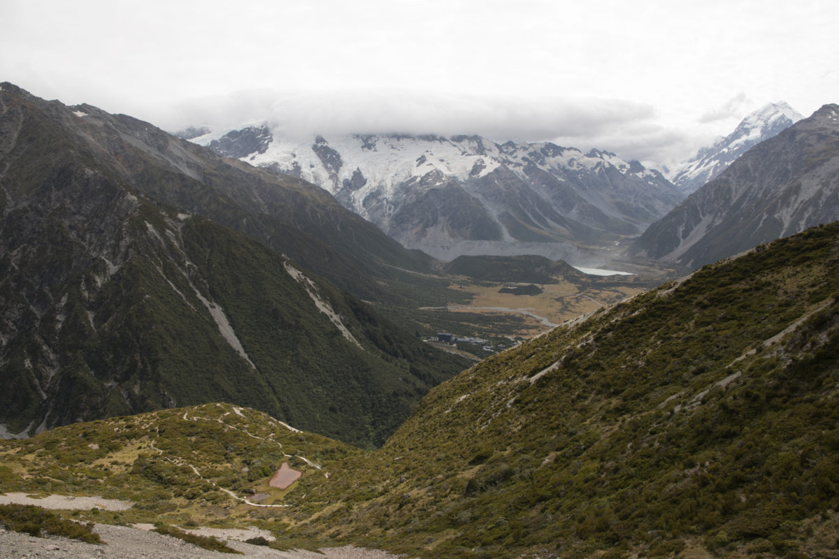
The beginning of the Red Tarns track has to be one of the most comfortable starts to a hike ever. The track is sealed and even outlined with stones through the bush. You can see the approximate location of the Red Tarns in the picture below where they are tucked on top of the round hill. There is a lot of variation in how long it might take you to reach the Red Tarns. As the track is so accessible it caters for a wide level of experienced hikers. Our crew managed to make it up to the tarns (one way) in approximately 35 minutes going at a relatively solid pace. Someone without the same level of fitness, will likely find that the times DOC indicate are reasonable.


Bottom: DOC sign close to the Mount Cook Village Public Shelter
Black Birch Stream Footbridge
The paved highway doesn’t last forever, soon enough the trail opens up from the bush and climbs a stop bank that leads to a footbridge over Black Birch stream. A number of stairs with railing mark the beginning of the climb towards the tarns. From the end of the bridge you enter the bush and begin making your way up towards the tarns. After some climbing the height of the shrubs and trees recedes and you get your first views out over Aoraki. There is a lot of satisfaction looking down on Mount Cook village below and realising just how far you’ve climbed.


Top Right: Richard taking strides along the path up along the Red Tarns Track
Bottom: Looking out over Mount Cook Village, Aoraki seen hiding behind the
Climbing the Red Tarns Track
Although the track is only 1.71 km to the plateau there’s a lot of elevation gain within a short distance. Take your time on the ascent, and appreciate the elevation you have gained as you make your way towards the plateau. Along sections of the it’s possible to look out over other hikers taking the track up to Red Tarns.


Bottom: Looking across to the Sealy Range, Kitchener and Waihi Pass seen right of the central image
Red Tarns Viewpoint
Once you finally reach the tarns reaches the plateau in which the tarns are found. On a good day you’ll have stunning views out over the Aroarokaehe Range it’s certainly an ideal spot to relax after the hike to this plateau. The walk around the tarns is made out by a well formed path and a few sections of board walks to protect the fragile flora and moss that makes up the area around the Red Tarns. A number of information boards can be found around the plateau, one at the end of the stairs along with a further beside the tarns themselves. Each of them has information about the area and its history accompanied by a wooden bench seat.


Middle: Ed (left) and Zach (right) taking in the view and their surroundings before descending back down to Mount Cook Village
Bottom: An information board near the beginning of the loop track around Red Tarns
Sebastopol
Walking the track up towards Red Tarns is also the beginning of the hike to the summit of Sebastopol (Mount/Mt Sebastopol) that can be accessed from a route leading off the south-eastern corner of the tarns track. A distinct route can be seen through the scree slope that leads up towards the summit of the peak. It is known as a “warm up peak” for mountaineers that are looking to climb some of the much more technically challenging and higher peaks in the national park. In the summer time it is a great opportunity for hikers and trampers to tackle a slightly more challenging route that doesn’t require technical alpine skills.
Time
4 hours
Distance
5.4 km
Ascent
806 m
Map
BY15
Grade
Moderate

Return journey via Red Tarns Track
The return journey back to the car park is a straightforward walk down. For someone with bad knees it can be a hard time managing so many steps all the way back down towards the car park. Getting down is a lot faster than the hike up, with such well defined steps it makes the hike down relatively easy. Appreciate and savour those views on your way down to the car park. You earned them.


Top Right: Ed making his way through the forested trees down along the path
Bottom: Ed tackling the last couple of steps before reaching the footbridge over Black Birch Stream