Canyon Creek is a stream and valley home to an iconic rock bivouac in Ahuriri Conservation Area. It’s situated far from civilisation, located off from state highway eight. Although there is a lot of time soaked up in travel to and from the destination, the hike itself makes the driving worthwhile. Large mountain ranges with cliff faces and waterfalls seamlessly falling from the snowmelt above, even in the heart of summer it’s an impressive and beautiful location to visit. Throughout the hike there are steep sections balanced out with flat sections through the bush and alongside the creeks fed by the Thurneysen Glacier. On the way up to Canyon Creek rock bivouac there are a number of campsites that would accomodate shorter journey. Especially if you have a younger family or aren’t able to make it the entire way Canyon Creek can still be an enjoyable hike.

44°10′40″S 169°36′05″E
In Detail
Canyon Creek is one of a handful of hikes in Canterbury where dogs are permitted to hike; as long as they are under effective control. Although no one in our party had a dog we were stoked to see a few dogs out along the trail during the weekend we spent in the mountains. If you’re planning on heading down to Canyon Creek it is well worth tying a trip to Mount Cook National Park and turning the adventure into a long weekend. It’s important to note that access to the end of Birchwood Road is really only four-wheel drive only. It is possible to reach a reasonable way down the road in a two-wheel drive however, if you are the only car, it’s a long way to call for help. Take your time along the access road, and allow plenty of time for the drive down.

Getting to Canyon Creek
Getting to the start of the track into Canyon Creek is one of the furtherest drives from Christchurch that is still within the Canterbury region. From Christchurch follow State Highway One (SH1) through until the turn-off to the inland scenic route turn-off towards Mount Cook National Park (SH79). Follow SH79 through to Fairlie until you make a right turn onto State Highway Eight (SH8). Follow SH8 until a large bend in the road after Omarama. A road sign marks the beginning of Arahuri Conservation Area where Birchwood Road begins. There’s approximately 30km of gravel road before you’ll reach the beginning of 12km of 4WD track that is not shown on Google Maps. I would not recommend doing this part of the track without a high clearance 4WD. Unless you’re a skilled driver and willing to risk getting stranded or damaging your 2WD vehicle, find yourself a 4WD for this trip.
Canyon Creek Route
The route in the Canyon Creek initially begins along the Ahuriri Valley Track before soon forking into the Canyon Creek Route. The route follows the creek up to the forest edge before it climbs through to the mid plateau. Eventually you’ll break out from the trees and into the grass for a short while interchanging between the two environments until you breakout onto a large scree slide where the mid plateau begins to close up. Follow the route until you reach the bottom of the falls where orange markers lead you up to the high plateau. Follow rock cairns from here onward until you eventually find your way to the rock bivvy. It’s an ideal spot to spend a night although cold, especially in the winter and spring.
[wp_mapbox_gl_js map_id=”8681″ height=”800px”]
GPX file download for Canyon Creek
Ahuriri Conservation Area Weather
As Ahuriri Conservation Area is on the eastern side of the Southern Alps it will often have a more consistent weather pattern than the West Coast. However, this can change within a short period of time. Between the seasons the landscape can change completely. In winter the waterfalls can freeze over and provide a playground for ice-climbing. Snow can cover the ground right from the initial walk in through the valley after a large snow storm. Ensure that you are extremely well prepared if you’re travelling in winter. In the summer and autumn months there isn’t the same risk from avalanches and snowfall that there is in winter making travel and access to Canyon Creek more achievable.
Canyon Creek – Birchwood Road End
The start of the walk into Canyon Creek begins along a wide smooth pathway down along the Ahuriri Valley, following through long grass and a gravel pathway. Initially you’ll take the same path as a track that leads down towards the head of the Ahuriri River where you can reach places such as Shamrock Hut, Hagens Hut and Top Hut. Well before these huts you must make the turn off to follow the feeder stream of Canyon Creek. This pathway continues being a mix of gravel and grasses with bush rising up from the base of surrounding mountain ranges.


Top: Grassy fields looking up the Ahuriri Valley. A number of other tracks and DOC huts can be accessed from the tracks around here
Bottom Left: The majority of the crew warming their legs up along the route in and along to the Canyon Creek Campsite
Bottom Right: Two stragglers from the party Ed and Richard making their way along the track as we attempt to get some sunshine on the upper body
Canyon Creek Track
Along the track there’s one significant stream crossing that you must make on your way to Canyon Creek rock bivouac which is to cross Little Canyon Creek. From here onward you’ll follow the true right of the river right the way to your destination. In other words there isn’t any more river crossings that need to be made. At the time of crossing a log bridged the gap making it easy enough to cross without getting wet shoes. If you’re someone that doesn’t like wet shoes, take them off for this one. There shouldn’t be any other opportunities to get your shoes soaked from here on in.


Bottom: Some happy hikers with dry boots after negotiating and balancing the log across the stream
Canyon Creek Bushline
After crossing over you’ll find that the track leads straight into the bush and begins climbing. It doesn’t hold back and mercilessly takes you up and up for a solid climb. It’s not vertical climbing but enough to get most people to start huffing and puffing there way up the hill. At the top you’ll get your first glimpses of the first plateau which makes up Canyon Creek valley. Alongside is a spectacular shear gorge which explains the climbing. The track continues on through the bush for before breaking out into tussock fields alongside Canyon Creek.


Clockwise from top left
Conor leading the way through the forest climb as we all began working up a sweat
Looking out from a viewpoint at the top of the forest climb on some large cliffs that make up a spectacular gorge through Canyon Creek.
A stoked and happy Ben relieved to be at the end of the climb and loving being outdoors
Richard followed by Conor pacing through the forest and they move in between the trees
Canyon Creek Route
The route alongside Canyon Creek is a gentle walk through the bush. Although you’ll have dealt with a steep climb up through the bush the mellow walk through the bush next to the river is a relaxing change. Walking along the Canyon Creek track alternates between walking through bush covered sections with tussock and the river right alongside. Walking alongside the river is much more relaxing as you approach the climb to the upper plateau.


Left: Conor taking the lead through a tussock filled section after breaking out of the bush for a short while as we continued along upstream
Right: Looking up towards the spectacular mountains that make up Canyon Creek
Campsite
A campsite stands on the edge of the bush line which is home to a large rock. It provides an interesting bouldering problem or extra shelter from the wind. It’s an easily identifiable landmark for a break and a bite to eat if you’re feeling peckish.


Top Right: Conor getting some bouldering practice in the middle of the forest
Bottom: A further campsite on the edge of the forest up to Canyon Creek marked by a large boulder and the remnants of a camp fire
Bush Breakout
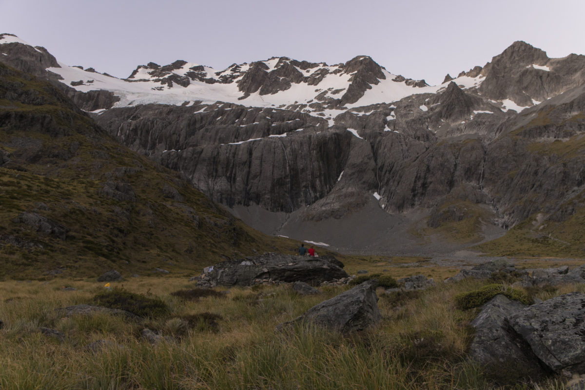
Beyond the campsite the bush line ends and you’re out in the open with the mountains surrounding you. The track does become more indistinct from this point. Not until the climb to the upper plateau will you see any further orange markers to guide you. It’s best to follow whatever goat tracks and cairns you are able to find. If in doubt follow the river, eventually you will get to a waterhole in the river where the climb begins. You can be sure to find a continuation of orange pole markers from here onwards.


Bottom: Looking up from the mid plateau towards the upper plateau
Climb to third Plateau Route
The climb to the third plateau begins alongside the rock face to the true right of the large pool seen below. It takes you through the grassy fields winding alongside the creek for a short while before beginning on a long switchback. The track throughout this section is well marked once you have found it. Due to the nature of the terrain it is difficult to lose your way along the trail.


Bottom: Zach and Tobi cranking out the ascent as we round a large sheer rock face along the beginning of the track
A highlight of the ascent is a waterfall that sits right alongside the track. It’s located in the perfect position for a shower if you feel inclined to cool off. The trail eventually will start to flatten off as you reach the upper plateau. It can become more indistinct as the gradient gives away, but as long as you are heading in the right direction (towards the crest of the waterfall) you’ll find yourself closing in on Canyon Creek rock bivouac.


Middle: Ascending through more exposed rock as the boys rounded out the ascent to the summit towards the upper plateau
Bottom: Looking across at a higher altitude over towards the upper plateau where the Canyon Creek Rock bivvy lies
Third Plateau
Finally as the gradient tails out you’ll find yourself having reached the third and final plateau. From the plateau you can see right the way back to the Ahuriri Valley and the journey to get there. Along your way there should be one significant stream crossing that you make early in the journey. From here onward it if a matter of following your sense of direction and the tracks that lead you to the rock bivouac. The panorama below looking across the third plateau shows the route along the true right of the river.;


Middle: A section of the hike that tastes as if it has hints of a Himalayan approach
Bottom: A panorama from the third plateau looking down the outlet stream that makes up the main water stream leading down the rock face
The final descent down to the bivouac is across a large scree slope with big loose boulders that you’ll hop across. Parts of the way are marked with rock cairns which help you to follow a route right the way to the rock bivouac.

Canyon Creek Rock Bivvy
A sleeping giant nestled in and amongst the tussock, from a distance it would be easy to discount the Canyon Creek Rock biv as just another large boulder amongst the field of surrounding boulders that could easily be dismissed. Once you reach the rock bivouac you can begin setting up your sleeping quarters. A tent tarp has been left along with a couple of blue tarps and dry grass for warmth and protection against the elements. Under the rock there is about space for 7 to 8 people. The exact location for the rock bivouac is given as E1328216, N5102551 or grid reference BZ14 282 025.

With a few other people at the rock bivouac the weekend that we arrived, others had already taken to tenting or bivvying under the stars instead. We did our cooking on a flat rock close to the rock bivouac and ate dinner up on top of the rock whilst the sun set and the stars came up. There’s enough room to dry out your towel or any clothes in the warmer months by hanging them from the rock. On the opposite side of the rock there’s even enough room for a small dog bivvy.


Clockwise from top left
Looking up towards the ridge line leading towards Mount Barth
The rock biv with a sleeping bag unfurled after a spectacular nights sleep under the rock while the sun rises
Tobi resting up after a big feed on top of the rock after a large feed while clothes and a towel dry on the rock after an evening swim.
Sun setting on the range leading down from the summit of Mount Barth looking south
Mount Barth & Surroundings
From the Rock Bivouac, summiting Mount Barth is a popular destination for those with some solid mountaineering experience. For more information on summiting this mountain check out the ClimbNZ database and Daniello Hegg’s Southern Alps Photography for more information on a summit attempt. It’s possible to reach the ridges of the mountain ranges either side without too much technical skills and a bit of scrambling in the summer months. It give a nice side-trip without having to carry all your usual gear that you take with you to set-up camp.

Return Journey from Canyon Creek
The return journey from Canyon Creek rock bivouac is far easier than trying to locate the rock bivouac for the first time. Retracing your footsteps you’ll always find yourself finding familiar surrounding right the way along. If you ever get really lost find the river and follow it along the true right. Eventually you’ll come across a section that will look familiar before it drops away and you’ll find markers and cairns to guide you back down to the mid-plateau.

The steep descent down is marked by the beginning of the poled markers. In damp conditions the track could definitely become a lot more challenging. Take care right the way back down and watch your step. Before you know it you’ll be back walking across the mid plateau well on your way along to the descent to the lower plateau and the Ahuriri River.


Middle Left: Zac and Tobi frolicking in the grass as we scoot back down to pick up the rest of the crew back at mid plateau camp
Middle Right: Tobi pausing in awe of his surroundings whilst Zach catches up
Bottom: Ed tailing the crew through the last section of forest before crossing Canyon Creek
Birchwood Road End
Once you’ve finally made it back out to Birchwood Road end ensure that you’ve left a solid amount of food in the back of the car and a beverage for everyone in the party in amongst a few ice packs. The picnic table at the start/end of the track is well utilised on a good day. Connect with the rest of your party, relax, yarn and enjoy your time in the mountains.

Dogs
Canyon Creek is one of a few hikes in Canterbury that allows dogs to come along with you on the hike. Although neither I nor any of the party had their own dog we got to appreciate seeing a good number of dogs out on the trail up and back from Canyon Creek. Although DOC does not require your dog to be on a lead it must be under effective control at all times. For more information about dogs on conservation land, refer to the Department of Conservation website.


Middle Left: A hungry dog looking to lick up a little bit of our dinners left overs. Little cutie.
Middle Right: Ed giving a friendly doggo a pat on our way back to the car
Bottom: A party of dogs basking next to Canyon Creek after a short weekend walk into the wilderness
Canyon Creek Crew
Kudos to this massive crew of troopers for tripping all the way down south from Christchurch to pick up Zach and Tobi from Twizel. Was a great trip away into the mountains with plenty of good memories made along the way. Don’t think I’ve ever gone so hard on buying food for a two day hike into the mountains for a group of people. Here’s to beautiful South Canterbury and more epic hiking trips. Cheers.
