Crooked Spur Hut is a backcountry hut in Te Kahui Kaupeka Conservation Area. The track along Bush Stream forms a part of the Te Araroa walkway, a through hike that stretches the length of New Zealand. It also a popular area among hunters. The walk into Crooked Spur Hut has numerous river crosses right the way to the hut. Many of the stream crossings are only ankle deep with and can be easily negotiated when the stream is at usual flow. The track is marked most of the way, although some sections the markers are sparse and it can take some time to get yourself back on track. Even though the track elevation from a map looks reasonably tame, the hike requires some good navigational skills and backcountry experience in the winter months with the increased risk of hypothermia.

43°37′34″S 170°50′31″E
In Detail
In winter the area around the Two Thumb Range can get brutally cold with a lot of snow falling during these times. The walk into Crooked Spur Hut is only a small part of the section of Te Araroa that makes its way through to Lake Tekapo. Parts of the walk are known for snowshoeing and ski touring as the trail leads closer towards Tekapo. There is a reasonable amount of game in the area also. At the time of returning from this overnight hike, a tahr jumped right out in front of us along the vehicle track back to the car. No matter what you intent may be for visiting the area if you are travelling in winter bring plenty of warm clothes, the stream crossings are freezing cold and the hut has no insulation at all, with very little firewood.

Getting there
Getting to the start of the track is right in the heart of Canterbury within close proximity to Mesopotamia station. Travelling from Christchurch, the drive is a long one. Follow State Highway One out to Rakaia turning right at the Mobil Station finding your way onto Thompsons Track. Turn onto Mayfield Valetta Road at Ashburton Forks, this should eventually transition to State Highway 72, the inland scenic route. Soon after you will reach Arundel, follow the signs onto Peel Forest Road. Peel Forest Road eventually turns into a long windy gravel road, a good chunk of time is spent covering these gravel roads. The road has a number of fords that must be crossed and in winter there are some icy patches to be dealt with. The car park has a large information board, toilet and plenty of parking spaces.
Route
The route into Crooked Spur Hut follows the Bush Stream track that makes up a part of Te Araroa. We found that sections of the track were well marked whilst other not so well. The track is well marked along a vehicle trail into the valley. As you come closer to Bush Stream the trail evidently disappears as you follow the river bed, crossing when you must until you find you’re next orange marker. There are two really important crossings to make along the way. The first is that you must ensure that you are on the true right (right as if you are following the river out to sea) to climb a small knoll. You must then descend this knoll and make the second crossing of Bush Stream before ascending the spur to Crooked Spur Hut.
[wp_mapbox_gl_js map_id=”3251″ height=”800px”]
Weather
MESOPOTAMIA WEATHERVehicle Track To Bush Stream
The start of the hike follows a well-formed vehicle track. At the time of walking the track, it was icy and muddy from a front that had recently passed through bringing with it a lot of snow. It would only really be suitable for a sturdy 4-wheel drive. It goes through a small gate and leads away from the farmland diving deep between the Sinclair Range and the Barbazon Range. The trail reaches a stopbank shortly after passing through the gate which marks the beginning of your walk up Bush Stream.

Bush Stream
Along the early stages of the track, it can be best to keep to the markers, however, you’ll soon find that the trail hasn’t been cut well and it’s easier to just follow the river up towards Sawtooth. There are numerous river crossings on this track which made it brutal to keep the feet and lower body warm. The water flow was relatively calm and required little difficulty to cross in most places. The snow on the rocks in places made walking quite slippery at times, using a pair of trekking poles can be advantageous.


Middle: Paul Making a crossing of one of the braids along Bush Stream
Bottom: Kevin and Isaac as they trudge through the snow and rock towards Sawtooth
Sawtooth
As the trail zig-zags it’s way up the valley eventually you encounter a point marked on the topographical map labelled sawtooth. It’s a good milestone in the hike and an opportunity to get something to eat and drink. I had been anxious when we had approached about finding a point to cross the river. As it turns out the river is still relatively calm through this section. It was with little trouble that we were able to find somewhere to cross.


Middle: Looking back to Sawtooth, a small gorge section in the river
Bottom: Matt taking a break after passing through Sawtooth
Forest Tracks
Leading on from sawtooth there are a number of sections in the track where the track has been cut out through the forest making the walk a little easier. It’s a good idea to keep your eyes peeled for any markers whilst you are following the river up the valley. These sections have little snow on the ground and aren’t nearly as slippery as the rocks along the riverbed.


Middle Left: Just before exiting the bush after another short section of trail that led through the forest
Middle Right: Looking up towards Mt Sinclair from Bush Stream as the clouds roll on by
Bottom: Taking cover in the bush as the river narrows
Parts of the track aren’t always that obvious, it’s important to keep an eye along the true left side of the river for any trails that delve into the bush. This is where we spent much of our time finding the way through the bush. Although the topographical map does not show that there is a track between sawtooth and the small knoll that you later climb. Certainly, there are segments of track cut through the bush that makes the hike up bush stream a lot easier.

Knoll
Before you reach the knoll where the track goes around the gorge section in the river you must ensure you are on the true right of the river (right side as the water flows). Scrambling up the knoll can be quite a challenge if the snow isn’t fresh and has hardened after some time. From hunters that passed us by they recommended having a pair of microspikes for better grip on the snow. It’s certainly possible to make it up the hill and through the gorge although it can be taxing. Among the forest, tree and shrubs are your best friend helping you to keep balance on the way up.

Climbing down from the knoll was the hardest part. Sliding wasn’t a pretty option but after a couple of bum shuffles, it does work a little. The descent back down to Bush Stream is steeper than the ascent but it is fairly short. From the top of the knoll, it’s possible to see Bush Stream below and the route to take down.


Bottom: Looking towards the Brabazon Range on top of the small knoll
Climb to Crooked Spur Hut
The climb up to Crooked Spur wasn’t quite as difficult as the climb up and descent down the knoll. There were a number of times where we would think that we were almost on the plateau where the hut wad only to find that there was another bend in the track. Towards the end of the day as the weather becomes colder and the energy starts to fade the last push can be quite hard. Thankfully there’s a stunning view right the way out the valley from the hut.


Bottom: A very happy Richard and an admiring Tim as they make the final few paces towards Crooked Spur Hut
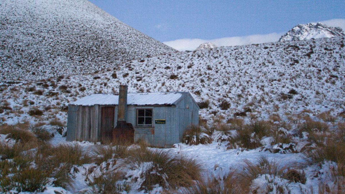
Crooked Spur Hut
It wasn’t long before we found ourselves on the home stretch to the hut. The sun setting made the views back down the valley gorgeous. We all made it into our night’s accommodation at Crooked Spur Hut before it got too cold and dark. The musters hut had the basics of bedding, an open fireplace and mattress’. It wasn’t long before we were warming the thin walls of Crooked Spur Hut. The hut has a toilet situated about 20m away from the hut. Fortunately, it is cold enough that there are no terrible smells nor any critters flying around with it being so cold up here in winter. Being a basic hut the cost of using the hut’s facilities were free of charge.


Bottom: Sunset looking over the Harper Range taken from Crooked Spur Hut
Return Journey
What I had been worried about was that in winter that all the snow would turn to glassy ice ending with us sliding our way down to Bush Stream. We returned the same way that we had come, this time absorbing the views were absolutely incredible as we looked back out on how far we had come. We managed to descend with a mixture of butt sliding and ploughing our own tracks. No harm or damage was done to ourselves or each other during this process.


Bottom: Richard digging the poles in to keep his balance as Kevin and Matt look on
Down & Out via Bush Stream
The shadows that Crooked Spur cast on the knoll made some of the descent a little more difficult but with a mixture of butt sliding and grabbing hold of trees it made it possible for us all to find our own creative ways back down the track. The sun certainly helped to soften and melt the snow in places along the way back down. The return journey had us following the true right of the river all the way out.


Middle: Trying to scoot around the vegetation as we all dreaded crossing back over the river
Bottom: Walking back along the riverbed comfortably making tracks back to the car
Following bush stream right the way back out the car, it was evident that the sun had melted away a good chunk of the snow that had been lying on the ground yesterday under the warm sun. It was a faster walk on the way out with a slight decline and knowing your way around the river rather than thinking and searching for the next marker.


Middle: Alvin admiring the mountains that we were leaving that day
Bottom: Walking back towards the car, Cloudy Peak Range centre frame
Crew
Finally a big shout out to all of my mates that tagged along on this hike and allowed me to snap them at some of their best and worst moments. Always a pleasure to catch up spin yarns, eat food and explore new areas together.

Photos, information captured and collected June 2018
Information not Correct?
Report an error