High up in the mountains lies Lake Man situated in Lake Sumner forest park. Perched up at 1500m there is a long walk into the lake to make it from State Highway 7 all the way up to the lake. The route from the highway to Lake Man bivouac is marked however beyond the bivouac there is no trail. It takes some good route finding skills to make it out of the dense bush between the bivouac and the open tussock up to the lake. Lake Man is a beautiful spot to set-up camp. When you’re up at the lake, you realise it was worth the struggle after a long walk to this paradise.

In Detail
he landscapes from this hike will not disappoint once you make it up to the lake. Walking up the Doubtful river can be tedious the scenery hardly changing for quite a while. This is much the same with hiking up the Kedron river towards Lake Man bivouac. The scenery has little variety and you are constantly climbing without much reward. Once you are out of the bush in the tussock you can finally appreciate how far you have come on the climb to Lake Man. It is a good spot to base yourself if you are keen to continue on your hike and summit Mt Lakeman. Due to the weather and how we exhausted, we were just making it to the lake we were set on just enjoying the lake itself.

Getting There
Route
Lake Man is located in Lewis Pass National Park on the most eastern side of the National Park. There is a small car park off to the side of where the track starts. It is easy to miss as you are driving along, make sure that you take care in finding the right pull-off bay as you are driving down State Highway 7. The exact location of the pull-off bay is given here. From here it is a short walk across the road to the start of the track that leads up to Lake Man Bivouac. On the return journey, the easiest option is to follow the same route as you take in, however, there is a route that would take a significant amount more time if you followed the track out via the Hope river.
[wp_mapbox_gl_js map_id=”3259″ height=”800px”]
Weather
ISLAND HILLS WEATHERThe Approach
The first situation you hit before you even start the hike is the fact you must cross the Boyle River. It isn’t an easy crossing at the best of times. Best practice for crossing a river safely is to link up with other members of your party to ensure you have good stability when you cross the river. We successfully kept our feet dry for the first part of the hike by wearing jandals/slides and then putting our boots on when we reached the start of the track. I would not recommend crossing the river solo, there was one lady that we had to end up helping across as she could not find a suitable crossing point.

Boyle River to Doubtful Hut
The section of the hike between Boyle river and Doubtful Hut is relatively straight forward. The track is mostly just about making your way along next to the river through the scrub and bush with a few side stream crossings along the way. The track meanders between the bush and it is not a problem if you don’t strictly follow the track. Keep an eye on the orange triangles, ensuring that you have seen one every so often to follow the Doubtful river. When we were walking the track there had been some big washouts that had devastated some of the track and the area. As long as you don’t find yourself walking to close to the bank side you won’t have an troubles at all.


Middle: Richard assessing the route to take as we battled through just a little more matagouri
Bottom: Washout and erosion from in the area
The closer we approached Doubtful Hut the well-formed the track threw is a few more inclines and descents. We were diverted deeper into the forest and the track became far easier to follow and was easy going underneath our feet. It was a good chance for us to pick up the pace under the treetops. As we approached the 2-hour mark of our hike there was a sense of achievement in making it to our first milestone of the day.


Bottom: On the home straight to Doubtful Hut
Doubtful Hut
There is an abundance of sandflies at this Doubtful hut. Unless you are someone that has strong genetics and sandflies will not penetrate your skin, this would not be my place of choice where you will want to spend the night. The hut is tidy with a fresh coat of paint however inside the hut it was littered with hoards of dead and alive sandflies. There are three bunks with only two mattresses in the hut. According to the Department of Conservation website, there are two bunks. As it is classed as a basic hut, it provides a free nights accommodation.
Bunk Beds
3 bunks
Facilities
Mattresses, Heating
Category
Basic


Bottom: The Doubtful River from just the clearing where Doubtful Hut lies
Lake Man Track junction
It takes approximately a further hour from Doubtful hut to make it to the Kedron river track junction. It’s a mellow hike along the river to the junction. There’s a lot of long grass throughout this area and patchy matagouri at times. There are a couple of shallow stream crossings to be negotiated but nothing that will go over your boots


Bottom: Taking on another one of the few unnecessary shallow river crossings that we made on the way up
Climbing to Lake Man Bivouac
As soon as you make it to the track junction the track begins to start climbing. It starts off gentle and smooth along the forest floor and then the track begins climbing up the valley towards the bivouac. It’s a long slog with hardly any views out. It’s important throughout this section to keep an eye on your footing. there are a number of mud patches where you can find yourself swimming in goop. Otherwise, as in the pictures, the forest floor is littered with small dead leaves, roots from the surrounding trees intermingled with a few rocks. It’s reasonably easy to find your way as you climb, the track is reasonably well defined over this


Bottom: Richard in the bottom of the frame making his way up the winding trail, Tyler up in front leading the way
It was supposed to take two and a half hours for this section of the hike, however, it definitely felt longer than that. The biggest relief was when got our first glimpse of the outlet from Lake Man through a small clearing in the bush. It isn’t much further, probably around another 20 to 30 minutes to reach the bivouac.

Navigating to Lake Man
In the

Bush Travel
The route through the forest starts from the outlet stream of Lake Man pictured below. If you follow the river up using your nose to choose the best route you should eventually find a cairn marking where you should cross the stream. We found that sticking to the true right bank of the river (left side of the river if you look upstream) as you the hike up, crossing where appropriate you should find your way to the tussock lands. It took us some time to find a clear route. As long as you keep the river within a sights view you can’t go wrong nor get lost.


Bottom: The crossing outlet from Lake Man in the forest as we made our way back to the
Open Tussock
The route is free-for-all once you make it out of the bush is just walking as you please, picking the best deer tracks that will take you through the tussock. There are two main landmarks to aim for as you head up to Lake Man. The first is a tussock basin where there are a number of cascading waterfalls, the second is the ridge to the true left of the creek (right of the waterfall as you climb). Having a pair of hiking poles throughout this section can be really helpful for maintaining your balance and improving your speed as you scale up towards the lake.


Bottom: Richard following stag highway 101 up towards the biv
From the bottom of the cascading waterfall outlet from Lake Man we chose to cross the stream and hike up to the ridge pictured to the right of the image below. From the below it looked like a gentle slope leading up to the lake but in reality it felt like much more of a slog as we ascended. Once again the deer tracks helped us find out way. The moss underfoot close to the lake was a blessing under our tired feet.


Middle: Tyler scoping out the route up ahead towards Lake Man
Bottom: The last ascent up towards Lake Man
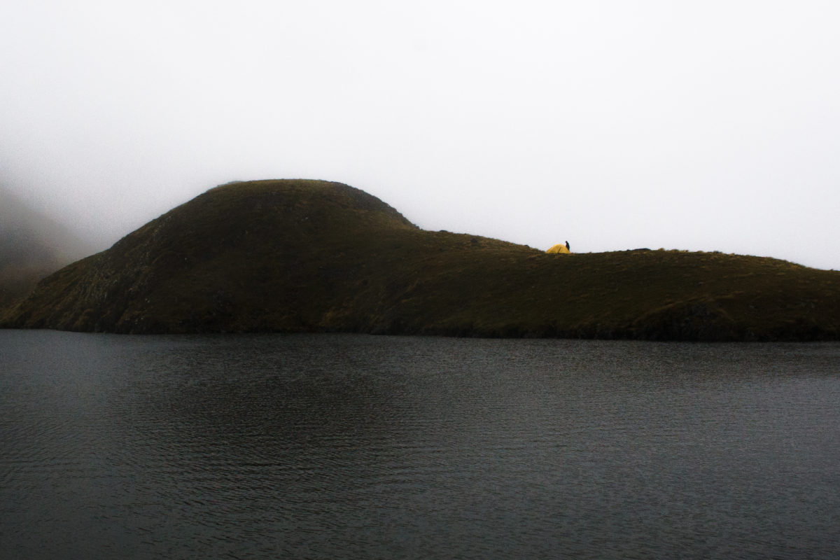
Lake Man
Lake Man has so many spots for you to park up your tent. The hut book showed few entries from those who have headed on from the bivouac to Lake Man. It makes sense with how difficult it can be to navigate to the lake itself. Once you arrive it’s incredibly beautiful. Finally, then it’s time to pop up the tent and put those feet up after a long walk in. The best campsites are around the eastern fringes of the lake we found. The rest of the area is quite steep or boggy, unsuitable for pitching your tent.


Bottom: Tyler looking down on camp from one of the small surrounding hills
Day 2
The second day we returned the same way we came. This time it was all downhill, right the way back to the car. With the clouds being so low and the weather being so damp it did make it hard for us to keep our footing as we descended back to the bivouac. We couldn’t see a lot with the cloud surrounding the lake but the further we descended below the clouds. The lower we descended the easier it became to see where we were heading, eventually leading us on to find the route back to Lake Man bivouac. The walk back following the track back towards the car was a grind but we were all thankful that it took less time that it did to get in the day before.
Time
7h
Distance
15.41 km
Descent
1135 m

Return Journey
Fortunately it wasn’t too hard to retrace our steps along the way down through the tussock. The most important part of the descent was to follow the outlet of Lake Man right the way down to the bush. From following our route we were able to retrace our footsteps back to the track we made the day before through the bush back to the biv.


Middle: Looking across to the Doubtful Range as the clouds break
Bottom: Tyler taking in the surroundings on the descent back down to Lake Man bivouac
The return journey from Lake Man bivouac was much easier going, we took fewer breaks along the way. We were easily able to cut off an hour from the walking time back to the car. The route finding was easy going on the way back. There was only one point in the track where the track crossed back into the bush after taking us along the bank that was more difficult to find. Once again we had to link up to cross the Boyle river to get back to the car but this time the boots were left on.


Bottom: Tyler making his way closer and closer to the end of the track