Scotties Hut (also known as Scotties Camp Hut) is an old musters hut in St James Conservation Area. The hut can be accessed on foot, by four wheel drive or mountain bike. It is one of a number of huts that are dotted along the St James Cycle Trail and the only hut that has vehicle access. During the winter months it’s not unusual to find snow next to the track after a storm has passed through. Usually lasts a day before turning the track and surroundings to mud. The walk is not technically demanding but rather a lot of distance to cover. The highlight of the trip is heading into Cow Stream Hot Pools, a side trip off the St James Cycle Trail. A short twenty minute excursion will lead you to a natural thermal spring.

42°25′49″S 172°38′22″E
In Detail
The timings that DOC suggest for walking into Scotties Hut and we found were excessive. At the St James Homestead it the sign stated it would take 6 hours to reach Scotties Hut. We found rather that it took us rather 6 hours to walk into Scotties Hut and find Cow Stream Hot Pools (which took some searching). Pack a towel and pair of trunks on this hike. You won’t regret carrying the extra weight in your pack. The second day with a larger elevation gain took 3.5 hours at a solid pace which is a reasonable time that could be achieved on the first day of walking too. If you’re heading in outside of the weekdays be sure to pack in a tent or allow time to reach Pools Hut.

Getting There
The drive into the start of the track to Scotties Hut takes you right through Hanmer Springs and over Jacks Pass via Clarence Valley Road. The road is narrow, steep in places and quite windy. It’s the type of road that you might expect find heading up to a ski field. In winter snow can cover the road making the terrain hazardous in places. If you drive a two-wheel drive I would recommend carrying chains in the back of the car and use them in case the road does become icy and covered in snow. The road along Tophouse Road has a number of potholes along the way. Take care, especially in a two wheel drive, keeping an eye out for them as you drive along the road.
Route
The track into Scotties Hut is easy to follow. The track is marked by blue coloured piping on a stake along the cycle trail. You can’t stray too far from the track, it is well defined muddy track that is wide enough almost all the way to walk two to three abreast. Along sections of the hike we found that walking next to the track proved to be easier. Especially during the winter the ground gets soft and muddy after snow and rain fall. As soon as a couple of vehicles drive through the track is caked in mud. A pair of walking poles can be beneficial through some of these muddy patches of terrain.
[wp_mapbox_gl_js map_id=”7087″ height=”800px”]
Weather
Unless there have been some extremely heavy rainfall and flooding in the area, many of the stream crossings that you make along this trip shouldn’t be an issue. Over the winter months it’s not unusual to find snow on the ground throughout the walk. The valley and surrounding area can get windy at the best of times. Pack or wear a good windproof layer to cut-out the wind chill along the walk. Especially if you do get damp or wet from some rain you can cool down extremely quickly.
Peters Valley Track
The Peters Valley Track is where you can start walking or biking the St James Cycle Trail (vehicle access is from further down Tophouse road). Park up next to St James Homestead, cross the small bridge and then you’re knocking off the kilometres towards Scotties Hut. A storm had passed through earlier with snow covering the ground. It is not necessary to have any alpine skills or any specialist equipment along the track during the winter months. Parts of the track were slippery which is expected.


Middle: Walking towards Peter’s Pass along the start of the Peters Valley Track
Bottom: A broken gate part way along the track towards Scotties Hut
Peters Pass
Peters Valley Track is a mellow rolling track cut into the side of the rolling hill that takes approximately an hour to reach Peters Pass where the track links up with the vehicle access track from Tophouse Road. As you approach the pass you’ll reach a board walk and then have views out over the Edwards River. There are two different tracks that take you down to the valley, one marked and one unmarked. The route description follows the marked track that we took, however, all of these trails will eventually bring you back to the St James Cycle Trail.


Bottom: The boys making there way across the tops of the mountains
St James Cycle Trail
The timings shown we found out were not accurate at all. On the way in by walking it took us an hour and twenty minutes to get to this intersection. It’s at this point that the track connects with the vehicle track from Tophouse Road and winds its way down to the riverside. The descent isn’t rough nor steep allowing you to almost run down the entire length of the track without stopping. It’s a great feeling on the legs but maybe a little harder on the knees. We found that from the turn-off to Scotties Hut it took approximately two and a half hours.


Middle Left: Zach making a start of the descent to the Edwards River
Middle Right: At the end of the descent the walking was relaxing
Bottom: The boys in formation as they make tracks along the flats
Edwards Valley
The mud logged sections of track start soon after you get down to the valley level. Fortunately in most cases alongside the track tussock covers most of the surrounding land making the walking relatively easy. Walking in the middle of the tyre tracks is also relatively stable although sometime they’ll end up getting thinner and collapsing on you. Blue markers (like the standard orange poled ones) mark the way along the track.


Bottom: Looking across the winding trail towards Scotties Hut, Zach taking a nap while having a chew on some grass
The mountains in the surrounding area (especially in winter) are a welcome comfort right the way along the track. They dominate the surrounding landscape. On the fifth and final major river crossing along the walk there is a T junction where the track splits two ways. Going west (right) will take you on to Scotties Hut, heading east (left) will take you to Cow Stream Hot Pools.


Bottom: Walking through some still patchy snow that had fallen alongside the Edwards River approaching the turn-off to Cow Stream Hot Pools
Cow Stream Hot Pools
Cow Stream Hot Pools is a small thermal spring located in St James Conservation Area. It’s one of a number of hot pools located in the northern reaches of Canterbury with others being found in Lake Sumner Forest Park. The walk from the St James Cycle Trail is short but can get ripped up and muddy in the winter months. The hot pools are accessible up to the terrace just above the pools and are only a short steep walk down to get to the pools from here.During the winter months the large temperature difference makes it comfortable to dip your feet in. The thermal pools are just the right temperature for a relaxing soak. After a days work, what more could you ask for?


Middle Left: Relaxing with just our feet in the pool before it got too dark
Middle Right: Zach and Mark making there way back along the track to the junction.
Bottom: Mark followed by Zach making there way along the four wheel drive track from Cow Stream Hot Pools
Turn Off to Scotties Hut
From the turn off to Cow Stream Hot Pools and Scotties Hut it takes approximately another half hour. The track is similar to much of the track that is previously covered with a slight descent as you make your way back down towards the Edwards River. There is one small stream crossing that you’ll come across but it’s possible to jump.


Left: Making one of a final couple of stream crossings before arriving at Scotties Hut
Right: Pacing through the grass to finally reach Scotties Hut and get a feed
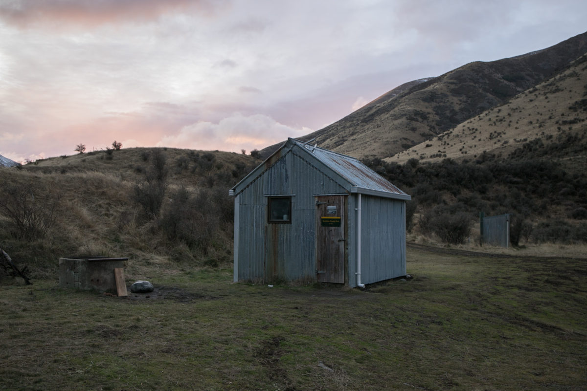
Scotties Hut
Scotties is a basic hut that is maintained and looked after the 4×4 community in conjunction with the Department of Conservation. There’s an open fire place outside and plenty of room to park up a truck. Water can be sourced from the stream with a number of tracks that can be found winding there way up and around the bank. LED lights and a solar panel has been installed in the hut making setting off a nice mood when you’re preparing some food after a days bike ride or just after some good chat into the night. There wasn’t any firewood stashed away in the back of the hut but if you were driving in, it would be a good shout to bring some wood in. Be a good citizen and sweep out the hut, wipe down the benches and fill in that hut book before you leave the hut.


Top: The hut at sunrise with the concrete open fire in the foreground, toilet and dog shelter just behind
Bottom Left: Scotties Camp Hut door at 665m above sea level
Bottom Right: Looking from the swing bridge across the Edwards River to Scotties Hut
Outside the hut is a twelve volt external voltage supply if you manage to have a use for it. On the opposite side of the track to the hut there is a toilet (long drop) and a dog kennel. The bunks were relatively comfortable although the top left bunk (from the doorway) can be a mission to climb into with there being no ladder that to reach the bunk. A beaten up frying pan that we found in amongst the long grass by the river was left in the hut for emergencies.


Top Right: Looking out from the little room along the St James Cycle Trail
Bottom: Abhi waking up after a solid 13 hours of sleep.
Return Journey
The return journey follows the exact same route as the way you walk in. With such a long walk ahead and knowing the track it’s pretty easy to just put your head down and grind out the last number of kilometres. We found that with a changing front coming in the wind was strong throughout the valley even in some of the more sheltered spots. If you decided to take your shoes off for the river crossings on the way in on the way back I can almost guarantee you that you won’t be bothered taking them off. Power on through and let the water cool your feet down. Wearing a pair of sneakers helped through the river crossing draining out after each crossing.


Bottom: Zach (left) taking the time to do his laces before the river crossing
The difference in the snow along the track was incredible in the last twenty four hours was noticeable with much of the snow disappearing from the previous day. The gentle slope down to St James Homestead is noticeable and helps with a faster pace down from Peter’s Pass. It’s not as noticeable on fresh legs on the way in but you definitely appreciate the descent when you make your way back to the car.


Middle: Looking down deep into the mountains as the snowy peaks rise
Bottom: Looking towards St James homestead. A welcome sight after the long return journey
Crew
A big shout out to this crew for making it up to Mount Brown on this hike. A half marathon walk on the first day and then a sixteen kilometre day to back it up. Definitely a well deserved beer back at the homestead.

Photos, information captured and collected August 2020
Information not Correct?
Report an error