Tarn Hut is a small basic hut nestled deep within the Canterbury Foothills with a beautiful tarn right on its doorstep. In the winter over the time snow can be found on the summit of Lilburne Hill and the tarn outside Tarn Hut freezes over. Return via the same direction to reach the hut or loopback via Youngman Stream Hut. Tarn Hut is a great weekend tramp for those with a good level of fitness and interested in beginning to explore more backcountry hikes. The hike into the turn off along the vehicle track is bland, but as you begin climbing the views and the thought of reaching the hut will make you forget the beginning. Ensure you take a tent and are prepared to camp out. The hut can be busy and you could just find yourself without a bed for the night.

43°35′31″S 171°05′07″E
In Detail
Hiking into Tarn Hut in winter is a great option if you are after something that won’t require any technical gear but still want to dip your feet in some of winters goodness. During our trip to Tarn Hut, most snow had fallen just after Tarn Hut and lasted until shortly after the descent from Lilburne Hill. With a pair of good boots and some gaiters to keep the snow out, you’ll really enjoy your time up and along the tops to Tarn Hut. If you were dedicated enough it would be possible to Mountain Bike into Tarn Hut via the vehicle track, although it would be a difficult climb. DOC has not stated anywhere that mountain biking is not allowed in the track so at this stage it could be possible.

Getting There
To get to the start of the track you drive out towards Oxford, driving along a windy unsealed road through to Lees Valley. The road is littered with potholes, much like a ski field access without such a steep gradient. The road winds its way through the Canterbury foothills bringing you to Lees Valley, a small plain between two ranges. The start of the 4WD track leading to the start of the track is not obvious, there are no clear signposts to indicate where to turn off the main road. I have tried my best to indicate the start of the track by giving the approximate coordinates to the location of the gate. The 4WD track is unmaintained and rough, I would not recommend driving this track unless you have a powerful 4WD that is capable of off-roading.
Route
The route we took, followed a loop with the first day accomplishing most of the climbing. The second day was much more about covering distance. The first day was reasonably straightforward, the track follows a wide vehicle track all the way to Tarn Hut where we stayed the night. The second day was a much longer day completing the remaining climb to the summit of Lilburne Hill, descending to Youngman Stream Hut and then travelling south and out via the Youngman Stream Track. The Youngman Stream track connects up to the vehicle track connects up with the parking area at the start of the track.
[wp_mapbox_gl_js map_id=”3715″ height=”800px”]
Weather & Conditions
The weather is usually reasonably fine throughout the Canterbury Foothills when the weather is poor on the West Coast. The walk into Youngman Stream hut is almost all undercover from the turn-off whilst the hike up to Tarn Hut provides little to no cover along the entire walk. Other hikes such as Mount Oxford or Pinchgut Hut offer far better protection from the elements if the weather is looking a little iffy. I highly recommend keeping an eye out for when it has recently snowed or there has been bad weather over the winter months. The scenery is so beautiful with the extra layer of snow and it does make the hike a little more interesting not to mention a lot colder.
Vehicle Track
The track begins along a mellow vehicle track through farmland with a few sheep here and there. The track follows the Ashley River for most of the hike. We took a quick stop for lunch close to the Asley River where there is a ford that you must cross to continue along the track. If you don’t enjoy getting your feet wet I would recommend taking your boots off for the crossing. There aren’t any other major stream or river crossings that you will need to make before the end of the day. Just after the crossing, there is a fork that creates the loop between Tarn Hut and Youngman Stream Hut.


Bottom: Warming the rubber of our boots on the vehicle track before the major climb up to the hut
Climbing to pt1250
The track up to Tarn Hut is easy to follow. It zig-zags up climbing steadily to pt1250 with a few straight stretches along the way. The views as you climb higher view you get increasingly better views of the surroundings. Out over Lees Valley the Canterbury plains and even Banks Pensinsula on a good day. The track continues on as a vehicle track and is relatively easy to follow. Over the summer months, you could possibly get away with a pair of sneakers along this part of the track.


Bottom: Looking back down the track towards Lees Valley where we had parked the car
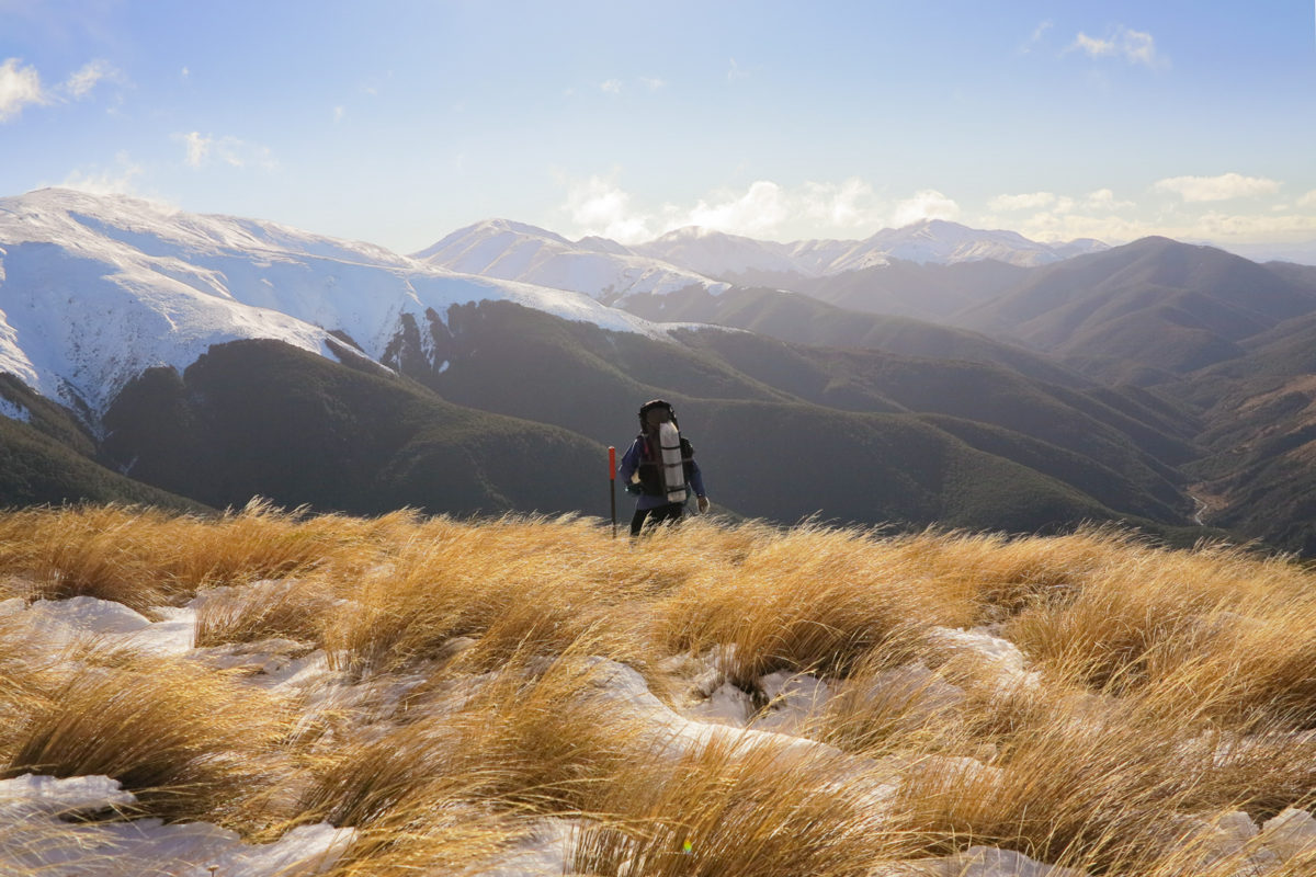
The track levels out significantly on from pt1250 there are still some moderate climbs that you have to tackle but nothing nearly as steep as what the initial climb was. There are a number of pine trees planted as windbreakers on the wat to Tarn Hut. They’re a good marker to indicate to show that you’re approximately halfway along the ridge to Tarn Hut. On a clear day, you’ll be able to make out the track from the summit of pt1250.


Middle: Looking along the snow-covered hills towards Tarn Hut
Bottom: Walking along the fringes of the bush just before we had some light snow flurries before reaching the hut
The Frozen Tarn
In winter the tarn freezes over (quite frequently I assume). With the altitude and the temperatures that it drops too, the ice was relatively thick. We heard no cracking whilst we were on the tarn. I would highly recommend carrying a buoyancy device some rope/cord in case there was a chance that the ice did crack and someone fell in. The tarn could be suitable for ice skating if the conditions were right and the temperature cold enough.


Bottom: Standing out on top of the ice at Tarn Hut having a lot of fun
Tarn Hut
Tarn Hut is well catered for a basic hut. It has extra supplies left from other hikers, a good stack of firewood when we visited and a small fireplace. Unfortunately, one unlucky person from our group had to sleep on the floor that night. If you are planning on spending the night at the hut dig yourself out a hole for a camp toilet and cover it before you leave. This helps detract any feral animals and commits to leaving no trace. From the small knoll next to the hut you can make out the city lights from Christchurch glimmering. The fire goes really well at the hut and had us toasty warm whilst it snowed throughout the night. Much of the wood is stored in the alcove before you enter the hut.


Bottom: The boys all ready for the day ahead after our night at Tarn Hut Richar, Paul, Kevin and Alvin (L to R)
Return Journey
The return journey described below follows the track up to the summit of Lilburne Hill before descending to the turnoff to Youngman Stream Hut before returning back alongside the Ashley River back out to the carpark. The route covers a lot more kilometres and the time is a rough estimate of how long it took us. For a more well equipped experienced group, I would think it could be done in under 6 hours. If you’re feeling exhausted after the previous day’s hike I would recommend hiking back the way you came. The summit of Lilburne Hill is pleasant with views of the upper Ashley River. You could do this as a side trip which would take approximately an hour and a half return.
Time
7.5 hours
Distance
14.3 km
Ascent
480 m

Lilburne Hill
The hike up to the summit of Lilburne Hill proved to be much harder work than we had initially expected. Over the summer and autumn months, I’m sure this section would be much easier to follow. Ploughing through the soft snow, we tried our best to follow old tracks and the poled markers. If it has snowed recently the poles provide a good sense of the direction to follow to the summit.


Middle: Looking out towards the summit of Lilburne Hill as the boys create a long trail as we plough through the snow
Bottom: Alvin taking a quick slash off the side of the hill while the cloud rolls through
Descent to Youngman Stream
The snow started to disappear soon after the steep descent down from the summit. It transitions quickly from snow to patchy tussock and before long you’ll approach the forest. The cloud cleared up for us on our trip back and we had beautiful views of the valley ahead of us down the Ashley River.


Bottom: Finding our way through the tussock back down the hill with a few soft falls along the way
As we descended to 1180m the track dropped into the treeline taking us down to Youngman Stream Hut. Cross a small river and find our way down to the hut (about a 5-minute walk) from the main track. It’s a good spot to stop for lunch although we found there can be a lot of sandflies around. The marker leading to the hut was obscured when we did this hike. Find an inlet that flows into the river and hike you should be able to uncover the track somewhere close by.

Youngman Stream Hut
Youngman stream hut has 6 bunks, there did seem to be a bit of an abundance of sandflies since the hut was so close to the river. There were good facilities with plenty of pots and pans, the beds looked like they would be a comfortable stay.
Youngman Stream Track
We pushed on, walking next to the river to get back to the car before we lost all light. The track along Youngman Stream was a little more challenging parts of the walk. Especially towards the end of the day, you start tiring out from a long day’s walking. It took us longer than expected to tackle this section. There were not many views throughout the remainder of the track, however, it was well cut well. There were a few hurdles including a few slips and fallen branches that we tackled however the rest was relatively straightforward.

The track opened up as we neared the junction to be pasture with tussock as we neared the fork. Making it back onto the 4WD track made the walking a lot easier. From there it wasn’t much longer until we were back to the car.

Crew
Shout out to these troopers, Kevin, Alvin, Paul and Richard for coming out with me on this hike all the way in our last year of high school. Tarn Hut was the first Overnight Hike that I ever led and organised all by myself and two of these boys first night staying in a high country hut. It’s a hike that we all look back on with fond memories.
